| News / Science News |
New map uncovers thousands of unseen seamounts on ocean floor
NSF | NOVEMBER 4, 2014
Scientists have created a new map of the world's seafloor, offering a more vivid picture of the structures that make up the deepest, least-explored parts of the ocean.
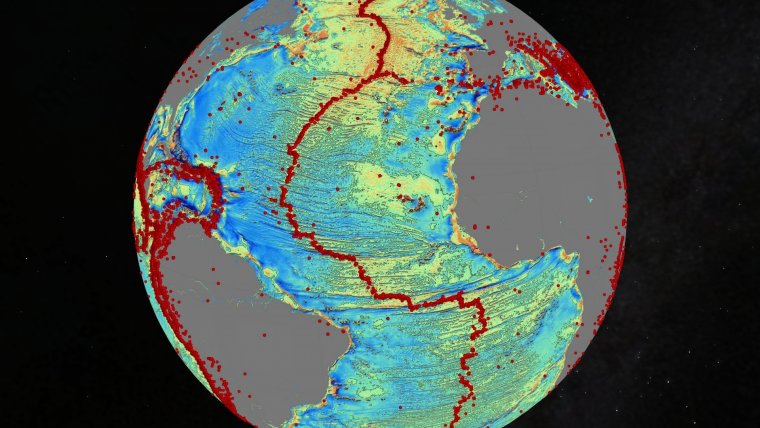
Gravity model of the N. Atlantic; red dots are earthquakes. Quakes are often related to seamounts. ![]()
The feat was accomplished by accessing two untapped streams of satellite data.
Thousands of previously uncharted mountains rising from the seafloor, called seamounts, have emerged through the map, along with new clues about the formation of the continents.
Combined with existing data and improved remote sensing instruments, the map, gives scientists new tools to investigate ocean spreading centers and little-studied remote ocean basins.
Earthquakes were also mapped. In addition, the researchers discovered that seamounts and earthquakes are often linked. Most seamounts were once active volcanoes, and so are usually found near tectonically active plate boundaries, mid-ocean ridges and subducting zones.
The new map is twice as accurate as the previous version produced nearly 20 years ago, say the researchers, who are affiliated with California's Scripps Institution of Oceanography (SIO) and other institutions.
Developed using a scientific model that captures gravity measurements of the ocean seafloor, the map extracts data from the European Space Agency's (ESA) CryoSat-2 satellite. CryoSat-2 primarily captures polar ice data but also operates continuously over the oceans.
Data also came from Jason-1, NASA's satellite that was redirected to map gravity fields during the last year of its 12-year mission. The map also provides a foundation for the upcoming new version of Google's ocean maps; it will fill large voids between shipboard depth profiles.
Previously unseen features include newly exposed continental connections across South America and Africa and new evidence for seafloor spreading ridges in the Gulf of Mexico. The ridges were active 150 million years ago and are now buried by mile-thick layers of sediment.
YOU MAY ALSO LIKE


