| Weather / Colorado Weather Temperature |
Weather in Aspen Pitkin County, Colorado
Current Conditions (Saturday, April 27, 2024 at 11:53 America/Denver time)
Temperature: 36°F (2°C) |
Forecast Overview
Sun Apr 28 
34°F 23°F 1°C -5°C Chance of snow all day.
detailsMon Apr 29 36°F 21°F 2°C -6°C Chance of snow until 6 pm.
detailsTue Apr 30 
41°F 19°F 5°C -7°C Chance of light snow in the morning and in the afternoon.
detailsWed May 1 
46°F 25°F 8°C -4°C Mostly sunny.
detailsThu May 2 
48°F 21°F 9°C -6°C Chance of rain in the afternoon. Chance of snow after 3 pm.
detailsFri May 3 39°F 9°F 4°C -13°C A few passing clouds.
detailsSat May 4 
48°F 21°F 9°C -6°C Times of sun and clouds.
detailsSun May 5 55°F 28°F 13°C -2°C A few passing clouds.
detailsMon May 6 
52°F 12°F 11°C -11°C Chance of snow in the afternoon and in the evening.
detailsTue May 7 
37°F 16°F 3°C -9°C Chance of light snow in the morning.
detailsWed May 8 
54°F 23°F 12°C -5°C Sunny skies.
detailsThu May 9 
55°F 32°F 13°C 0°C Considerable cloudiness.
detailsFri May 10 48°F 16°F 9°C -9°C Chance of snow in the afternoon.
detailsSat May 11 34°F 14°F 1°C -10°C Chance of snow in the morning and in the afternoon.
details
Detailed Forecast
| Sunday, April 28 | sunrise: 06:12 sunset: 19:57 |
| Low around 24°F (-5°C), high around 34°F (1°C). Chance of snow all day (from 3 am to midnight). The precipitation may fall as scattered showers of varying intensity. Estimated precipitation: 1.16 in (29.5625 mm). Overcast skies. Wind: 5 mph (7 km/h). |
| Time | Skies | Conditions | Temp | Wind | Humidity | Soil Moisture |
| 00:00 03:00 | Overcast. Precipitation: 0 in (0.0625 mm). | 27°F (-3°C) | 5 mph (7 km/h) | 85% | 0.283% | |
| 03:00 06:00 | Chance of light snow. Precipitation: 0.01 in (0.1875 mm). | 27°F (-3°C) | 2 mph (3 km/h) | 90% | 0.283% | |
| 06:00 09:00 | Chance of light snow. Precipitation: 0.04 in (0.9375 mm). | 31°F (-0°C) | 2 mph (3 km/h) | 86% | 0.284% | |
| 09:00 12:00 | Chance of scattered snow showers. Precipitation: 0.12 in (2.9375 mm). | 33°F (0°C) | 1 mph (2 km/h) | 91% | 0.302% | |
| 12:00 15:00 | Chance of snow. Precipitation: 0.32 in (8.0625 mm). | 32°F (-0°C) | 4 mph (7 km/h) | 96% | 0.329% | |
| 15:00 18:00 | Chance of snow. Precipitation: 0.35 in (8.8125 mm). | 29°F (-1°C) | 4 mph (6 km/h) | 97% | 0.334% | |
| 18:00 21:00 | Chance of snow. Precipitation: 0.25 in (6.25 mm). | 28°F (-2°C) | 3 mph (5 km/h) | 99% | 0.332% | |
| 21:00 00:00 | Chance of snow. Precipitation: 0.09 in (2.3125 mm). | 27°F (-3°C) | 3 mph (5 km/h) | 98% | 0.33% |
| Monday, April 29 | sunrise: 06:11 sunset: 19:58 |
| Low around 21°F (-6°C), high around 36°F (2°C). Chance of snow until 6 pm. The precipitation may fall as scattered showers of varying intensity. Estimated precipitation: 0.28 in (7.1875 mm). Considerable cloudiness. Wind: 6 mph (10 km/h). |
| Time | Skies | Conditions | Temp | Wind | Humidity | Soil Moisture |
| 00:00 03:00 | Chance of snow. Precipitation: 0.05 in (1.1875 mm). | 26°F (-3°C) | 3 mph (5 km/h) | 99% | 0.328% | |
| 03:00 06:00 | Chance of snow. Precipitation: 0.06 in (1.5625 mm). | 24°F (-4°C) | 3 mph (5 km/h) | 99% | 0.326% | |
| 06:00 09:00 | Chance of snow. Precipitation: 0.04 in (1.0625 mm). | 29°F (-2°C) | 6 mph (10 km/h) | 95% | 0.327% | |
| 09:00 12:00 | Chance of light snow. Precipitation: 0.03 in (0.75 mm). | 32°F (0°C) | 4 mph (7 km/h) | 93% | 0.354% | |
| 12:00 15:00 | Chance of scattered snow showers. Precipitation: 0.04 in (1.125 mm). | 35°F (2°C) | 6 mph (9 km/h) | 86% | 0.395% | |
| 15:00 18:00 | Chance of scattered snow showers. Precipitation: 0.05 in (1.1875 mm). | 35°F (2°C) | 5 mph (8 km/h) | 84% | 0.393% | |
| 18:00 21:00 | Partly cloudy. Precipitation: 0.01 in (0.25 mm). | 22°F (-5°C) | 4 mph (7 km/h) | 94% | 0.375% | |
| 21:00 00:00 | Times of clear skies and clouds. Precipitation: 0 in (0.0625 mm). | 21°F (-6°C) | 5 mph (9 km/h) | 95% | 0.365% |
| Tuesday, April 30 | sunrise: 06:10 sunset: 19:59 |
| Low around 19°F (-7°C), high around 42°F (5°C). Chance of light snow from 9 am to 6 pm. Estimated precipitation: 0.03 in (0.75 mm). More clouds than sun. Wind: 7 mph (12 km/h). |
| Time | Skies | Conditions | Temp | Wind | Humidity | Soil Moisture |
| 00:00 03:00 | Mostly clear, with a few passing clouds. Precipitation: 0 in (0.0625 mm). | 22°F (-5°C) | 4 mph (7 km/h) | 96% | 0.36% | |
| 03:00 06:00 | Clear. | 20°F (-7°C) | 6 mph (9 km/h) | 95% | 0.358% | |
| 06:00 09:00 | Sunny. | 33°F (1°C) | 3 mph (5 km/h) | 82% | 0.361% | |
| 09:00 12:00 | Chance of light snow. Precipitation: 0 in (0.125 mm). | 39°F (4°C) | 4 mph (6 km/h) | 66% | 0.38% | |
| 12:00 15:00 | Chance of light snow. Precipitation: 0.01 in (0.25 mm). | 41°F (5°C) | 5 mph (9 km/h) | 67% | 0.388% | |
| 15:00 18:00 | Chance of light snow. Precipitation: 0.01 in (0.25 mm). | 40°F (5°C) | 6 mph (9 km/h) | 70% | 0.38% | |
| 18:00 21:00 | Partly cloudy. Precipitation: 0 in (0.0625 mm). | 30°F (-1°C) | 7 mph (12 km/h) | 85% | 0.366% | |
| 21:00 00:00 | Mostly clear. | 30°F (-1°C) | 7 mph (11 km/h) | 80% | 0.358% |
| Wednesday, May 1 | sunrise: 06:09 sunset: 20:00 |
| Low around 24°F (-4°C), high around 47°F (8°C). Mostly sunny. Wind: 11 mph (17 km/h). |
| Time | Skies | Conditions | Temp | Wind | Humidity | Soil Moisture |
| 00:00 03:00 | Considerable cloudiness. | 27°F (-3°C) | 6 mph (9 km/h) | 83% | 0.354% | |
| 03:00 06:00 | Clear. | 24°F (-4°C) | 5 mph (7 km/h) | 88% | 0.353% | |
| 06:00 09:00 | Sunny. | 37°F (3°C) | 5 mph (7 km/h) | 70% | 0.354% | |
| 09:00 12:00 | Sunny. | 44°F (7°C) | 9 mph (14 km/h) | 48% | 0.358% | |
| 12:00 15:00 | Sunny. | 47°F (8°C) | 10 mph (16 km/h) | 44% | 0.35% | |
| 15:00 18:00 | Sunny. | 46°F (8°C) | 11 mph (17 km/h) | 49% | 0.333% | |
| 18:00 21:00 | Clear. | 31°F (-1°C) | 7 mph (10 km/h) | 75% | 0.321% | |
| 21:00 00:00 | A few passing clouds. | 31°F (-0°C) | 7 mph (12 km/h) | 71% | 0.314% |
| Thursday, May 2 | sunrise: 06:07 sunset: 20:01 |
| Low around 21°F (-6°C), high around 48°F (9°C). Chance of rain early in the afternoon (between 12 pm and 3 pm). Chance of snow after 3 pm. The precipitation may fall as scattered showers of varying intensity. Estimated precipitation: 0.46 in (11.75 mm). Mostly cloudy skies. Wind: 16 mph (26 km/h). |
| Time | Skies | Conditions | Temp | Wind | Humidity | Soil Moisture |
| 00:00 03:00 | Mostly clear. | 31°F (-1°C) | 8 mph (13 km/h) | 72% | 0.311% | |
| 03:00 06:00 | Times of clear skies and clouds. | 30°F (-1°C) | 7 mph (11 km/h) | 73% | 0.309% | |
| 06:00 09:00 | Overcast. | 43°F (6°C) | 7 mph (11 km/h) | 48% | 0.308% | |
| 09:00 12:00 | Mostly cloudy. Precipitation: 0 in (0.0625 mm). | 47°F (8°C) | 16 mph (26 km/h) | 44% | 0.303% | |
| 12:00 15:00 | Chance of light rain. Precipitation: 0.03 in (0.75 mm). | 46°F (8°C) | 15 mph (24 km/h) | 54% | 0.296% | |
| 15:00 18:00 | Chance of scattered snow showers. Precipitation: 0.07 in (1.875 mm). | 37°F (3°C) | 11 mph (17 km/h) | 92% | 0.299% | |
| 18:00 21:00 | Chance of snow. Precipitation: 0.18 in (4.5625 mm). | 32°F (-0°C) | 6 mph (9 km/h) | 100% | 0.312% | |
| 21:00 00:00 | Chance of snow. Precipitation: 0.18 in (4.5 mm). | 21°F (-6°C) | 4 mph (6 km/h) | 96% | 0.306% |
| Friday, May 3 | sunrise: 06:06 sunset: 20:02 |
| Low around 9°F (-13°C), high around 39°F (4°C). Estimated precipitation: 0.05 in (1.375 mm). A few passing clouds. Wind: 6 mph (9 km/h). |
| Time | Skies | Conditions | Temp | Wind | Humidity | Soil Moisture |
| 00:00 03:00 | Overcast. Precipitation: 0.05 in (1.25 mm). | 17°F (-8°C) | 4 mph (6 km/h) | 92% | 0.302% | |
| 03:00 06:00 | Partly cloudy. Precipitation: 0 in (0.125 mm). | 9°F (-13°C) | 3 mph (4 km/h) | 99% | 0.301% | |
| 06:00 09:00 | Times of sun and clouds. | 23°F (-5°C) | 4 mph (6 km/h) | 63% | 0.301% | |
| 09:00 12:00 | Sunny. | 32°F (0°C) | 3 mph (6 km/h) | 57% | 0.305% | |
| 12:00 15:00 | Sunny. | 38°F (3°C) | 1 mph (2 km/h) | 49% | 0.308% | |
| 15:00 18:00 | Sunny. | 38°F (3°C) | 1 mph (1 km/h) | 46% | 0.305% | |
| 18:00 21:00 | Clear. | 24°F (-5°C) | 6 mph (9 km/h) | 83% | 0.301% | |
| 21:00 00:00 | Clear. | 22°F (-5°C) | 5 mph (9 km/h) | 83% | 0.3% |
| Saturday, May 4 | sunrise: 06:05 sunset: 20:03 |
| Low around 21°F (-6°C), high around 48°F (9°C). Times of sun and clouds. Wind: 13 mph (21 km/h). |
| Time | Skies | Conditions | Temp | Wind | Humidity | Soil Moisture |
| 00:00 03:00 | Clear. | 21°F (-6°C) | 6 mph (9 km/h) | 78% | 0.3% | |
| 03:00 06:00 | Clear. | 22°F (-6°C) | 6 mph (10 km/h) | 70% | 0.301% | |
| 06:00 09:00 | Sunny. | 39°F (4°C) | 5 mph (8 km/h) | 40% | 0.302% | |
| 09:00 12:00 | Partly cloudy. | 45°F (7°C) | 12 mph (19 km/h) | 34% | 0.304% | |
| 12:00 15:00 | Mostly cloudy. | 47°F (9°C) | 13 mph (21 km/h) | 33% | 0.301% | |
| 15:00 18:00 | Overcast. | 46°F (8°C) | 9 mph (15 km/h) | 42% | 0.295% | |
| 18:00 21:00 | Times of clear skies and clouds. | 29°F (-1°C) | 5 mph (8 km/h) | 71% | 0.291% | |
| 21:00 00:00 | Clear. | 29°F (-2°C) | 6 mph (10 km/h) | 63% | 0.288% |
| Sunday, May 5 | sunrise: 06:04 sunset: 20:04 |
| Low around 29°F (-2°C), high around 55°F (13°C). A few passing clouds. Wind: 14 mph (23 km/h). |
| Time | Skies | Conditions | Temp | Wind | Humidity | Soil Moisture |
| 00:00 03:00 | Mostly clear. | 29°F (-2°C) | 6 mph (10 km/h) | 60% | 0.287% | |
| 03:00 06:00 | Clear. | 30°F (-1°C) | 8 mph (12 km/h) | 60% | 0.287% | |
| 06:00 09:00 | Sunny. | 47°F (8°C) | 11 mph (17 km/h) | 35% | 0.287% | |
| 09:00 12:00 | Sunny. | 52°F (11°C) | 13 mph (21 km/h) | 32% | 0.283% | |
| 12:00 15:00 | Overcast. | 55°F (13°C) | 14 mph (23 km/h) | 29% | 0.274% | |
| 15:00 18:00 | Considerable cloudiness. | 52°F (11°C) | 13 mph (21 km/h) | 38% | 0.268% | |
| 18:00 21:00 | Clear. | 40°F (4°C) | 8 mph (13 km/h) | 45% | 0.265% | |
| 21:00 00:00 | Clear. | 41°F (5°C) | 11 mph (17 km/h) | 38% | 0.263% |
| Monday, May 6 | sunrise: 06:03 sunset: 20:05 |
| Low around 13°F (-11°C), high around 52°F (11°C). Chance of snow late in the afternoon and in the evening (between 3 pm and 9 pm). Estimated precipitation: 0.29 in (7.25 mm). More clouds than sun. Wind: 21 mph (33 km/h). |
| Time | Skies | Conditions | Temp | Wind | Humidity | Soil Moisture |
| 00:00 03:00 | Clear. | 38°F (3°C) | 9 mph (15 km/h) | 41% | 0.261% | |
| 03:00 06:00 | Clear. | 35°F (2°C) | 8 mph (14 km/h) | 46% | 0.26% | |
| 06:00 09:00 | Sunny. | 46°F (8°C) | 14 mph (22 km/h) | 28% | 0.257% | |
| 09:00 12:00 | Sunny. | 50°F (10°C) | 17 mph (28 km/h) | 22% | 0.249% | |
| 12:00 15:00 | Overcast. | 51°F (10°C) | 21 mph (33 km/h) | 22% | 0.241% | |
| 15:00 18:00 | Chance of light snow. Precipitation: 0.01 in (0.1875 mm). | 38°F (3°C) | 9 mph (14 km/h) | 68% | 0.238% | |
| 18:00 21:00 | Chance of snow. Precipitation: 0.26 in (6.625 mm). | 22°F (-5°C) | 9 mph (14 km/h) | 96% | 0.239% | |
| 21:00 00:00 | Overcast. Precipitation: 0.02 in (0.4375 mm). | 15°F (-10°C) | 3 mph (5 km/h) | 99% | 0.239% |
| Tuesday, May 7 | sunrise: 06:02 sunset: 20:06 |
| Low around 15°F (-9°C), high around 37°F (3°C). Chance of light snow early in the morning (until 9 am). Estimated precipitation: 0.06 in (1.625 mm). Considerable cloudiness. Wind: 9 mph (15 km/h). |
| Time | Skies | Conditions | Temp | Wind | Humidity | Soil Moisture |
| 00:00 03:00 | Chance of light snow. Precipitation: 0.01 in (0.375 mm). | 17°F (-8°C) | 5 mph (8 km/h) | 96% | 0.24% | |
| 03:00 06:00 | Chance of light snow. Precipitation: 0.02 in (0.5625 mm). | 18°F (-8°C) | 6 mph (9 km/h) | 96% | 0.241% | |
| 06:00 09:00 | Chance of light snow. Precipitation: 0.02 in (0.5 mm). | 25°F (-4°C) | 9 mph (15 km/h) | 75% | 0.242% | |
| 09:00 12:00 | Partly cloudy. Precipitation: 0 in (0.125 mm). | 33°F (0°C) | 9 mph (15 km/h) | 61% | 0.246% | |
| 12:00 15:00 | Overcast. Precipitation: 0 in (0.0625 mm). | 35°F (2°C) | 7 mph (11 km/h) | 64% | 0.25% | |
| 15:00 18:00 | Mostly cloudy. | 36°F (2°C) | 4 mph (7 km/h) | 66% | 0.252% | |
| 18:00 21:00 | Clear. | 25°F (-4°C) | 5 mph (7 km/h) | 92% | 0.252% | |
| 21:00 00:00 | Clear. | 24°F (-4°C) | 5 mph (8 km/h) | 91% | 0.253% |
| Wednesday, May 8 | sunrise: 06:01 sunset: 20:07 |
| Low around 24°F (-5°C), high around 54°F (12°C). Sunny skies. Wind: 6 mph (10 km/h). |
| Time | Skies | Conditions | Temp | Wind | Humidity | Soil Moisture |
| 00:00 03:00 | Clear. | 24°F (-4°C) | 5 mph (9 km/h) | 88% | 0.254% | |
| 03:00 06:00 | Clear. | 24°F (-5°C) | 5 mph (8 km/h) | 82% | 0.256% | |
| 06:00 09:00 | Sunny. | 41°F (5°C) | 1 mph (2 km/h) | 47% | 0.258% | |
| 09:00 12:00 | Sunny. | 50°F (10°C) | 4 mph (6 km/h) | 35% | 0.261% | |
| 12:00 15:00 | Sunny. | 54°F (12°C) | 5 mph (9 km/h) | 32% | 0.258% | |
| 15:00 18:00 | Sunny. | 52°F (11°C) | 5 mph (8 km/h) | 40% | 0.255% | |
| 18:00 21:00 | Mostly clear, with a few passing clouds. | 35°F (2°C) | 5 mph (8 km/h) | 76% | 0.254% | |
| 21:00 00:00 | A few passing clouds. | 34°F (1°C) | 6 mph (10 km/h) | 72% | 0.254% |
| Thursday, May 9 | sunrise: 06:00 sunset: 20:08 |
| Low around 32°F (0°C), high around 56°F (13°C). Considerable cloudiness. Wind: 15 mph (24 km/h). |
| Time | Skies | Conditions | Temp | Wind | Humidity | Soil Moisture |
| 00:00 03:00 | Clear. | 33°F (0°C) | 8 mph (12 km/h) | 68% | 0.253% | |
| 03:00 06:00 | Overcast. | 33°F (1°C) | 8 mph (12 km/h) | 63% | 0.252% | |
| 06:00 09:00 | Overcast. | 48°F (9°C) | 3 mph (6 km/h) | 40% | 0.252% | |
| 09:00 12:00 | Overcast. | 55°F (13°C) | 9 mph (14 km/h) | 29% | 0.249% | |
| 12:00 15:00 | Overcast. | 54°F (12°C) | 15 mph (24 km/h) | 33% | 0.246% | |
| 15:00 18:00 | Overcast. | 51°F (10°C) | 14 mph (22 km/h) | 34% | 0.243% | |
| 18:00 21:00 | Clear. | 37°F (3°C) | 5 mph (9 km/h) | 70% | 0.243% | |
| 21:00 00:00 | Clear. | 35°F (2°C) | 7 mph (11 km/h) | 44% | 0.243% |
| Friday, May 10 | sunrise: 05:59 sunset: 20:09 |
| Low around 16°F (-9°C), high around 48°F (9°C). Chance of snow during the afternoon (between 12 pm and 6 pm). Estimated precipitation: 0.73 in (18.625 mm). Partly cloudy skies. Wind: 13 mph (20 km/h). |
| Time | Skies | Conditions | Temp | Wind | Humidity | Soil Moisture |
| 00:00 03:00 | Mostly clear. | 34°F (1°C) | 6 mph (9 km/h) | 46% | 0.244% | |
| 03:00 06:00 | Sunny. | 30°F (-1°C) | 5 mph (8 km/h) | 52% | 0.244% | |
| 06:00 09:00 | Mostly sunny. | 44°F (6°C) | 6 mph (10 km/h) | 38% | 0.243% | |
| 09:00 12:00 | Overcast. | 47°F (9°C) | 13 mph (20 km/h) | 35% | 0.24% | |
| 12:00 15:00 | Chance of snow. Precipitation: 0.17 in (4.25 mm). | 37°F (3°C) | 5 mph (8 km/h) | 88% | 0.255% | |
| 15:00 18:00 | Chance of snow. Precipitation: 0.34 in (8.5625 mm). | 33°F (0°C) | 9 mph (15 km/h) | 99% | 0.293% | |
| 18:00 21:00 | Times of clear skies and clouds. Precipitation: 0.23 in (5.75 mm). | 20°F (-7°C) | 3 mph (5 km/h) | 97% | 0.285% | |
| 21:00 00:00 | Clear. Precipitation: 0 in (0.0625 mm). | 16°F (-9°C) | 3 mph (4 km/h) | 94% | 0.283% |
| Saturday, May 11 | sunrise: 05:58 sunset: 20:10 |
| Low around 13°F (-10°C), high around 35°F (1°C). Chance of snow from 9 am to 6 pm. The precipitation may fall as scattered showers of varying intensity. Estimated precipitation: 0.15 in (3.875 mm). Mostly cloudy skies. Wind: 12 mph (19 km/h). |
| Time | Skies | Conditions | Temp | Wind | Humidity | Soil Moisture |
| 00:00 03:00 | A few passing clouds. Precipitation: 0 in (0.125 mm). | 15°F (-9°C) | 2 mph (4 km/h) | 96% | 0.283% | |
| 03:00 06:00 | Mostly sunny. | 14°F (-10°C) | 3 mph (6 km/h) | 96% | 0.284% | |
| 06:00 09:00 | Partly cloudy. | 27°F (-3°C) | 7 mph (11 km/h) | 70% | 0.285% | |
| 09:00 12:00 | Chance of light snow. Precipitation: 0.03 in (0.8125 mm). | 31°F (-1°C) | 10 mph (16 km/h) | 67% | 0.298% | |
| 12:00 15:00 | Chance of scattered snow showers. Precipitation: 0.06 in (1.5625 mm). | 33°F (0°C) | 10 mph (16 km/h) | 69% | 0.319% | |
| 15:00 18:00 | Chance of snow. Precipitation: 0.04 in (1.125 mm). | 34°F (1°C) | 12 mph (19 km/h) | 65% | 0.327% | |
| 18:00 21:00 | Clear. Precipitation: 0.01 in (0.25 mm). | 23°F (-5°C) | 2 mph (3 km/h) | 87% | 0.327% | |
| 21:00 00:00 | Overcast. | 22°F (-6°C) | 3 mph (5 km/h) | 85% | 0.327% |
Climate Chart
» Aspen Pitkin County Climate Chart
Places with a similar climate: Laramie (WY), Butte (MT), Driggs City, Teton County (ID).
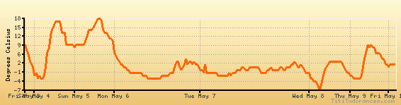
Temperature variation graph for the last seven days
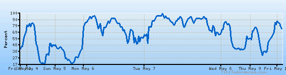
Humidity Variation Graph
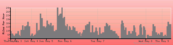
Wind speed
Weather Station: Aspen, Aspen-Pitkin County Airport (latitude 39-13-44N, longitude 106-52-10W)
Local Time:
Aspen Pitkin County is in the "America/Denver" timezone.
The "America/Denver" timezone uses a Standard Time (ST) / Daylight Saving Time (DST) alternation scheme, and it currently is in DST (since Sunday, 10 March 2024, 03:00 AM local time). During DST, the timezone abbreviation is MDT and the offset to Universal Time (UTC, GMT or Zulu) is -6:00 hours.
Aspen Pitkin County will exit DST (returning to standard time) on Sunday, 3 November 2024, at 02:00 AM local time, when clocks will be turned backward 1 hour to Sunday, 3 November 2024, 01:00 AM local standard time. During ST, the timezone abbreviation is MST and the offset to UTC will be -7:00 hours.
Weather and Temperature in Colorado