| Weather / Canada Weather Temperature |
Weather in Grise Fiord, Canada
Current Conditions (Saturday, April 27, 2024 at 19:00 America/Iqaluit time)
Temperature: 7°F (-14°C) |
Forecast Overview
Mon Apr 29 
23°F 5°F -5°C -15°C Chance of snow almost all day.
detailsTue Apr 30 
9°F -4°F -13°C -20°C Mostly cloudy skies.
detailsWed May 1 
5°F -6°F -15°C -21°C Mostly sunny, with a few passing clouds.
detailsThu May 2 
9°F -6°F -13°C -21°C More sun than clouds.
detailsFri May 3 9°F -2°F -13°C -19°C Times of sun and clouds.
detailsSat May 4 14°F -2°F -10°C -19°C Overcast skies.
detailsSun May 5 19°F 10°F -7°C -12°C Chance of snow all night and day.
detailsMon May 6 
19°F 3°F -7°C -16°C Chance of snow before sunrise and in the evening.
detailsTue May 7 10°F -2°F -12°C -19°C Mostly sunny.
detailsWed May 8 
14°F 1°F -10°C -17°C Sunny skies.
detailsThu May 9 14°F 1°F -10°C -17°C Sunny skies.
detailsFri May 10 18°F 1°F -8°C -17°C Mostly sunny, with a few passing clouds.
detailsSat May 11 
30°F 9°F -1°C -13°C Chance of light snow in the morning and in the afternoon.
detailsSun May 12 
32°F 27°F -0°C -3°C Chance of light snow in the morning.
details
Detailed Forecast
| Monday, April 29 | sunrise: (MidnightSun/PolarNight) sunset: (MidnightSun/PolarNight) |
| Low around 4°F (-15°C), high around 23°F (-5°C). Chance of snow most of the night and day, except evening between 5 pm and 8 pm. Estimated precipitation: 0.17 in (4.375 mm). Overcast skies. Wind: 7 mph (11 km/h). |
| Time | Skies | Conditions | Temp | Wind | Humidity | Soil Moisture |
| 23:00 02:00 | Chance of snow. Precipitation: 0.05 in (1.25 mm). | 20°F (-6°C) | 4 mph (7 km/h) | 95% | 0.423% | |
| 02:00 05:00 | Chance of snow. Precipitation: 0.04 in (1.125 mm). | 12°F (-11°C) | 4 mph (7 km/h) | 96% | 0.423% | |
| 05:00 08:00 | Chance of light snow. Precipitation: 0.02 in (0.5625 mm). | 13°F (-11°C) | 3 mph (5 km/h) | 95% | 0.423% | |
| 08:00 11:00 | Chance of light snow. Precipitation: 0.02 in (0.5 mm). | 13°F (-11°C) | 6 mph (9 km/h) | 93% | 0.423% | |
| 11:00 14:00 | Chance of light snow. Precipitation: 0.02 in (0.5 mm). | 12°F (-11°C) | 7 mph (11 km/h) | 93% | 0.423% | |
| 14:00 17:00 | Chance of light snow. Precipitation: 0.01 in (0.3125 mm). | 11°F (-12°C) | 6 mph (10 km/h) | 92% | 0.423% | |
| 17:00 20:00 | Overcast. Precipitation: 0 in (0.0625 mm). | 8°F (-13°C) | 5 mph (8 km/h) | 96% | 0.423% | |
| 20:00 23:00 | Chance of light snow. Precipitation: 0 in (0.0625 mm). | 4°F (-15°C) | 4 mph (6 km/h) | 97% | 0.423% |
| Tuesday, April 30 | sunrise: (MidnightSun/PolarNight) sunset: (MidnightSun/PolarNight) |
| Low around -4°F (-20°C), high around 8°F (-13°C). Estimated precipitation: 0 in (0.125 mm). Mostly cloudy skies. Wind: 5 mph (9 km/h). |
| Time | Skies | Conditions | Temp | Wind | Humidity | Soil Moisture |
| 23:00 02:00 | Mostly cloudy. Precipitation: 0 in (0.0625 mm). | 0°F (-18°C) | 3 mph (4 km/h) | 99% | 0.423% | |
| 02:00 05:00 | More sun than clouds. | -2°F (-19°C) | 2 mph (4 km/h) | 99% | 0.423% | |
| 05:00 08:00 | Mostly cloudy. | -1°F (-18°C) | 3 mph (4 km/h) | 97% | 0.423% | |
| 08:00 11:00 | Considerable cloudiness. | 1°F (-17°C) | 5 mph (7 km/h) | 92% | 0.423% | |
| 11:00 14:00 | Overcast. | 3°F (-16°C) | 5 mph (8 km/h) | 89% | 0.423% | |
| 14:00 17:00 | Overcast. | 3°F (-16°C) | 5 mph (9 km/h) | 88% | 0.423% | |
| 17:00 20:00 | Partly cloudy. Precipitation: 0 in (0.0625 mm). | 3°F (-16°C) | 4 mph (7 km/h) | 94% | 0.423% | |
| 20:00 23:00 | Overcast. | -2°F (-19°C) | 3 mph (5 km/h) | 97% | 0.422% |
| Wednesday, May 1 | sunrise: (MidnightSun/PolarNight) sunset: (MidnightSun/PolarNight) |
| Low around -5°F (-21°C), high around 5°F (-15°C). Mostly sunny, with a few passing clouds. Wind: 5 mph (9 km/h). |
| Time | Skies | Conditions | Temp | Wind | Humidity | Soil Moisture |
| 23:00 02:00 | More clouds than sun. | -4°F (-20°C) | 4 mph (7 km/h) | 95% | 0.422% | |
| 02:00 05:00 | Considerable cloudiness. | -3°F (-20°C) | 4 mph (6 km/h) | 93% | 0.422% | |
| 05:00 08:00 | Sunny. | -3°F (-19°C) | 3 mph (5 km/h) | 92% | 0.422% | |
| 08:00 11:00 | A few passing clouds. | 3°F (-16°C) | 1 mph (1 km/h) | 84% | 0.422% | |
| 11:00 14:00 | Sunny. | 5°F (-15°C) | 1 mph (2 km/h) | 81% | 0.422% | |
| 14:00 17:00 | Sunny. | 4°F (-15°C) | 0 mph (1 km/h) | 87% | 0.422% | |
| 17:00 20:00 | Sunny. | -1°F (-18°C) | 3 mph (5 km/h) | 91% | 0.422% | |
| 20:00 23:00 | Sunny. | -5°F (-21°C) | 5 mph (9 km/h) | 91% | 0.422% |
| Thursday, May 2 | sunrise: (MidnightSun/PolarNight) sunset: (MidnightSun/PolarNight) |
| Low around -6°F (-21°C), high around 8°F (-13°C). More sun than clouds. Wind: 5 mph (8 km/h). |
| Time | Skies | Conditions | Temp | Wind | Humidity | Soil Moisture |
| 23:00 02:00 | Sunny. | -6°F (-21°C) | 5 mph (8 km/h) | 88% | 0.422% | |
| 02:00 05:00 | Sunny. | -5°F (-21°C) | 5 mph (8 km/h) | 85% | 0.422% | |
| 05:00 08:00 | Overcast. | -0°F (-18°C) | 3 mph (5 km/h) | 83% | 0.422% | |
| 08:00 11:00 | Partly cloudy. | 7°F (-14°C) | 3 mph (4 km/h) | 74% | 0.422% | |
| 11:00 14:00 | Considerable cloudiness. | 8°F (-13°C) | 3 mph (4 km/h) | 78% | 0.422% | |
| 14:00 17:00 | Mostly cloudy. | 8°F (-13°C) | 3 mph (5 km/h) | 84% | 0.422% | |
| 17:00 20:00 | Sunny. | 2°F (-17°C) | 1 mph (2 km/h) | 97% | 0.422% | |
| 20:00 23:00 | More sun than clouds. | -2°F (-19°C) | 4 mph (7 km/h) | 95% | 0.422% |
| Friday, May 3 | sunrise: (MidnightSun/PolarNight) sunset: (MidnightSun/PolarNight) |
| Low around -3°F (-19°C), high around 9°F (-13°C). Times of sun and clouds. Wind: 6 mph (9 km/h). |
| Time | Skies | Conditions | Temp | Wind | Humidity | Soil Moisture |
| 23:00 02:00 | Overcast. | -1°F (-18°C) | 3 mph (5 km/h) | 91% | 0.422% | |
| 02:00 05:00 | Partly cloudy. | -1°F (-19°C) | 4 mph (6 km/h) | 89% | 0.422% | |
| 05:00 08:00 | Partly cloudy. | 2°F (-17°C) | 2 mph (4 km/h) | 86% | 0.422% | |
| 08:00 11:00 | Times of sun and clouds. | 7°F (-14°C) | 2 mph (3 km/h) | 78% | 0.422% | |
| 11:00 14:00 | Sunny. | 9°F (-13°C) | 3 mph (4 km/h) | 80% | 0.422% | |
| 14:00 17:00 | Sunny. | 8°F (-13°C) | 2 mph (3 km/h) | 89% | 0.422% | |
| 17:00 20:00 | Sunny. | 3°F (-16°C) | 4 mph (6 km/h) | 92% | 0.422% | |
| 20:00 23:00 | Mostly sunny. | -1°F (-18°C) | 6 mph (9 km/h) | 92% | 0.422% |
| Saturday, May 4 | sunrise: (MidnightSun/PolarNight) sunset: (MidnightSun/PolarNight) |
| Low around -3°F (-19°C), high around 13°F (-10°C). Estimated precipitation: 0.02 in (0.4375 mm). Overcast skies. Wind: 6 mph (9 km/h). |
| Time | Skies | Conditions | Temp | Wind | Humidity | Soil Moisture |
| 23:00 02:00 | Overcast. | -2°F (-19°C) | 6 mph (9 km/h) | 89% | 0.422% | |
| 02:00 05:00 | Overcast. | 3°F (-16°C) | 4 mph (7 km/h) | 85% | 0.422% | |
| 05:00 08:00 | Overcast. | 9°F (-13°C) | 3 mph (6 km/h) | 78% | 0.422% | |
| 08:00 11:00 | Overcast. | 11°F (-12°C) | 4 mph (7 km/h) | 79% | 0.422% | |
| 11:00 14:00 | Overcast. Precipitation: 0 in (0.125 mm). | 13°F (-11°C) | 5 mph (8 km/h) | 88% | 0.422% | |
| 14:00 17:00 | Overcast. Precipitation: 0.01 in (0.1875 mm). | 13°F (-10°C) | 5 mph (9 km/h) | 89% | 0.422% | |
| 17:00 20:00 | Overcast. Precipitation: 0 in (0.0625 mm). | 12°F (-11°C) | 5 mph (8 km/h) | 92% | 0.422% | |
| 20:00 23:00 | Overcast. Precipitation: 0 in (0.0625 mm). | 11°F (-12°C) | 5 mph (8 km/h) | 93% | 0.422% |
| Sunday, May 5 | sunrise: (MidnightSun/PolarNight) sunset: (MidnightSun/PolarNight) |
| Low around 11°F (-12°C), high around 19°F (-7°C). Chance of snow all night and day. Estimated precipitation: 0.36 in (9.25 mm). Overcast skies. Wind: 8 mph (13 km/h). |
| Time | Skies | Conditions | Temp | Wind | Humidity | Soil Moisture |
| 23:00 02:00 | Chance of light snow. Precipitation: 0.01 in (0.25 mm). | 11°F (-12°C) | 5 mph (8 km/h) | 95% | 0.422% | |
| 02:00 05:00 | Chance of light snow. Precipitation: 0.01 in (0.3125 mm). | 12°F (-11°C) | 5 mph (9 km/h) | 95% | 0.422% | |
| 05:00 08:00 | Chance of light snow. Precipitation: 0.03 in (0.875 mm). | 14°F (-10°C) | 6 mph (10 km/h) | 94% | 0.422% | |
| 08:00 11:00 | Chance of light snow. Precipitation: 0.03 in (0.8125 mm). | 15°F (-9°C) | 7 mph (12 km/h) | 94% | 0.422% | |
| 11:00 14:00 | Chance of snow. Precipitation: 0.06 in (1.625 mm). | 17°F (-9°C) | 8 mph (13 km/h) | 94% | 0.422% | |
| 14:00 17:00 | Chance of snow. Precipitation: 0.08 in (2.0625 mm). | 18°F (-8°C) | 7 mph (12 km/h) | 95% | 0.422% | |
| 17:00 20:00 | Chance of snow. Precipitation: 0.07 in (1.75 mm). | 18°F (-8°C) | 7 mph (12 km/h) | 95% | 0.422% | |
| 20:00 23:00 | Chance of snow. Precipitation: 0.06 in (1.5625 mm). | 19°F (-7°C) | 6 mph (10 km/h) | 96% | 0.422% |
| Monday, May 6 | sunrise: (MidnightSun/PolarNight) sunset: (MidnightSun/PolarNight) |
| Low around 4°F (-16°C), high around 19°F (-7°C). Chance of snow before sunrise (from 11 pm to 5 am) and in the evening (from 5 pm to 8 pm). Estimated precipitation: 0.16 in (4 mm). Mostly cloudy skies. Wind: 10 mph (17 km/h). |
| Time | Skies | Conditions | Temp | Wind | Humidity | Soil Moisture |
| 23:00 02:00 | Chance of snow. Precipitation: 0.05 in (1.3125 mm). | 18°F (-8°C) | 8 mph (12 km/h) | 96% | 0.422% | |
| 02:00 05:00 | Chance of snow. Precipitation: 0.07 in (1.6875 mm). | 18°F (-8°C) | 10 mph (17 km/h) | 96% | 0.422% | |
| 05:00 08:00 | Mostly cloudy. Precipitation: 0.03 in (0.875 mm). | 11°F (-12°C) | 8 mph (14 km/h) | 100% | 0.422% | |
| 08:00 11:00 | Considerable cloudiness. | 10°F (-12°C) | 3 mph (5 km/h) | 96% | 0.422% | |
| 11:00 14:00 | Sunny. | 14°F (-10°C) | 3 mph (4 km/h) | 89% | 0.422% | |
| 14:00 17:00 | More clouds than sun. | 13°F (-11°C) | 3 mph (5 km/h) | 95% | 0.422% | |
| 17:00 20:00 | Chance of light snow. Precipitation: 0 in (0.0625 mm). | 8°F (-13°C) | 1 mph (1 km/h) | 98% | 0.422% | |
| 20:00 23:00 | Mostly cloudy. Precipitation: 0 in (0.0625 mm). | 4°F (-16°C) | 6 mph (9 km/h) | 96% | 0.422% |
| Tuesday, May 7 | sunrise: (MidnightSun/PolarNight) sunset: (MidnightSun/PolarNight) |
| Low around -2°F (-19°C), high around 10°F (-12°C). Estimated precipitation: 0 in (0.0625 mm). Mostly sunny. Wind: 10 mph (16 km/h). |
| Time | Skies | Conditions | Temp | Wind | Humidity | Soil Moisture |
| 23:00 02:00 | Times of sun and clouds. Precipitation: 0 in (0.0625 mm). | 0°F (-18°C) | 8 mph (13 km/h) | 92% | 0.421% | |
| 02:00 05:00 | Mostly sunny, with a few passing clouds. | -1°F (-19°C) | 9 mph (14 km/h) | 92% | 0.421% | |
| 05:00 08:00 | Sunny. | 2°F (-16°C) | 8 mph (13 km/h) | 89% | 0.421% | |
| 08:00 11:00 | Sunny. | 7°F (-14°C) | 8 mph (12 km/h) | 86% | 0.421% | |
| 11:00 14:00 | Sunny. | 10°F (-12°C) | 8 mph (12 km/h) | 83% | 0.421% | |
| 14:00 17:00 | Sunny. | 10°F (-12°C) | 8 mph (12 km/h) | 85% | 0.421% | |
| 17:00 20:00 | Sunny. | 6°F (-14°C) | 9 mph (14 km/h) | 84% | 0.421% | |
| 20:00 23:00 | Mostly sunny. | 3°F (-16°C) | 10 mph (16 km/h) | 84% | 0.421% |
| Wednesday, May 8 | sunrise: (MidnightSun/PolarNight) sunset: (MidnightSun/PolarNight) |
| Low around 1°F (-17°C), high around 14°F (-10°C). Sunny skies. Wind: 10 mph (17 km/h). |
| Time | Skies | Conditions | Temp | Wind | Humidity | Soil Moisture |
| 23:00 02:00 | Mostly sunny, with a few passing clouds. | 1°F (-17°C) | 10 mph (17 km/h) | 84% | 0.421% | |
| 02:00 05:00 | Sunny. | 2°F (-17°C) | 9 mph (15 km/h) | 83% | 0.421% | |
| 05:00 08:00 | Sunny. | 6°F (-14°C) | 8 mph (13 km/h) | 81% | 0.421% | |
| 08:00 11:00 | Sunny. | 11°F (-12°C) | 6 mph (9 km/h) | 78% | 0.421% | |
| 11:00 14:00 | Sunny. | 13°F (-10°C) | 5 mph (9 km/h) | 75% | 0.421% | |
| 14:00 17:00 | Sunny. | 13°F (-11°C) | 6 mph (9 km/h) | 78% | 0.421% | |
| 17:00 20:00 | Sunny. | 8°F (-13°C) | 8 mph (12 km/h) | 80% | 0.421% | |
| 20:00 23:00 | Mostly sunny. | 4°F (-16°C) | 9 mph (15 km/h) | 81% | 0.421% |
| Thursday, May 9 | sunrise: (MidnightSun/PolarNight) sunset: (MidnightSun/PolarNight) |
| Low around 1°F (-17°C), high around 14°F (-10°C). Sunny skies. Wind: 10 mph (15 km/h). |
| Time | Skies | Conditions | Temp | Wind | Humidity | Soil Moisture |
| 23:00 02:00 | Times of sun and clouds. | 1°F (-17°C) | 10 mph (15 km/h) | 84% | 0.421% | |
| 02:00 05:00 | Sunny. | 2°F (-17°C) | 9 mph (14 km/h) | 84% | 0.421% | |
| 05:00 08:00 | Sunny. | 6°F (-14°C) | 7 mph (11 km/h) | 82% | 0.421% | |
| 08:00 11:00 | Sunny. | 11°F (-12°C) | 5 mph (7 km/h) | 78% | 0.421% | |
| 11:00 14:00 | Sunny. | 14°F (-10°C) | 3 mph (5 km/h) | 76% | 0.421% | |
| 14:00 17:00 | Sunny. | 13°F (-10°C) | 3 mph (4 km/h) | 82% | 0.421% | |
| 17:00 20:00 | Sunny. | 8°F (-13°C) | 5 mph (8 km/h) | 83% | 0.421% | |
| 20:00 23:00 | Sunny. | 3°F (-16°C) | 7 mph (11 km/h) | 82% | 0.421% |
| Friday, May 10 | sunrise: (MidnightSun/PolarNight) sunset: (MidnightSun/PolarNight) |
| Low around 1°F (-17°C), high around 17°F (-8°C). Mostly sunny, with a few passing clouds. Wind: 12 mph (19 km/h). |
| Time | Skies | Conditions | Temp | Wind | Humidity | Soil Moisture |
| 23:00 02:00 | Sunny. | 1°F (-17°C) | 7 mph (11 km/h) | 81% | 0.421% | |
| 02:00 05:00 | Sunny. | 2°F (-16°C) | 6 mph (10 km/h) | 79% | 0.421% | |
| 05:00 08:00 | Sunny. | 8°F (-14°C) | 5 mph (8 km/h) | 78% | 0.421% | |
| 08:00 11:00 | Sunny. | 14°F (-10°C) | 4 mph (7 km/h) | 74% | 0.421% | |
| 11:00 14:00 | Partly cloudy. | 16°F (-9°C) | 5 mph (8 km/h) | 74% | 0.421% | |
| 14:00 17:00 | Sunny. | 16°F (-9°C) | 8 mph (12 km/h) | 77% | 0.421% | |
| 17:00 20:00 | Considerable cloudiness. | 14°F (-10°C) | 10 mph (17 km/h) | 81% | 0.421% | |
| 20:00 23:00 | Sunny. | 11°F (-12°C) | 12 mph (19 km/h) | 78% | 0.421% |
| Saturday, May 11 | sunrise: (MidnightSun/PolarNight) sunset: (MidnightSun/PolarNight) |
| Low around 9°F (-13°C), high around 29°F (-1°C). Chance of light snow from 8 am to 5 pm. Estimated precipitation: 0.07 in (1.8125 mm). Overcast skies. Wind: 12 mph (19 km/h). |
| Time | Skies | Conditions | Temp | Wind | Humidity | Soil Moisture |
| 23:00 02:00 | Overcast. | 10°F (-12°C) | 12 mph (19 km/h) | 76% | 0.421% | |
| 02:00 05:00 | Overcast. | 13°F (-11°C) | 10 mph (17 km/h) | 79% | 0.421% | |
| 05:00 08:00 | Overcast. | 19°F (-7°C) | 7 mph (11 km/h) | 80% | 0.421% | |
| 08:00 11:00 | Chance of light snow. Precipitation: 0.01 in (0.375 mm). | 23°F (-5°C) | 6 mph (10 km/h) | 90% | 0.421% | |
| 11:00 14:00 | Chance of light snow. Precipitation: 0.01 in (0.3125 mm). | 27°F (-3°C) | 5 mph (8 km/h) | 93% | 0.421% | |
| 14:00 17:00 | Chance of light snow. Precipitation: 0.04 in (0.9375 mm). | 29°F (-2°C) | 5 mph (7 km/h) | 94% | 0.421% | |
| 17:00 20:00 | Overcast. Precipitation: 0 in (0.0625 mm). | 28°F (-2°C) | 4 mph (6 km/h) | 95% | 0.421% | |
| 20:00 23:00 | Overcast. Precipitation: 0 in (0.125 mm). | 27°F (-3°C) | 4 mph (7 km/h) | 95% | 0.421% |
| Sunday, May 12 | sunrise: (MidnightSun/PolarNight) sunset: (MidnightSun/PolarNight) |
| Low around 26°F (-3°C), high around 32°F (-0°C). Chance of light snow early in the morning, between 2 am and 8 am. Estimated precipitation: 0.04 in (1.0625 mm). Mostly cloudy skies. Wind: 5 mph (8 km/h). |
| Time | Skies | Conditions | Temp | Wind | Humidity | Soil Moisture |
| 23:00 02:00 | Overcast. Precipitation: 0 in (0.0625 mm). | 27°F (-3°C) | 4 mph (7 km/h) | 94% | 0.421% | |
| 02:00 05:00 | Chance of light snow. Precipitation: 0.01 in (0.375 mm). | 28°F (-2°C) | 5 mph (8 km/h) | 96% | 0.421% | |
| 05:00 08:00 | Chance of light snow. Precipitation: 0.02 in (0.5625 mm). | 30°F (-1°C) | 4 mph (7 km/h) | 96% | 0.421% | |
| 08:00 11:00 | Overcast. Precipitation: 0 in (0.0625 mm). | 32°F (-0°C) | 3 mph (5 km/h) | 98% | 0.421% | |
| 11:00 14:00 | Overcast. | 31°F (-0°C) | 3 mph (5 km/h) | 98% | 0.421% | |
| 14:00 17:00 | Partly cloudy. | 31°F (-1°C) | 1 mph (2 km/h) | 97% | 0.422% | |
| 17:00 20:00 | More sun than clouds. | 30°F (-1°C) | 1 mph (2 km/h) | 95% | 0.422% | |
| 20:00 23:00 | More clouds than sun. | 28°F (-2°C) | 2 mph (3 km/h) | 96% | 0.422% |
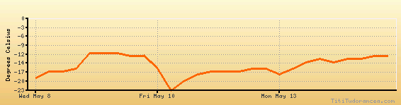
Temperature variation graph for the last seven days
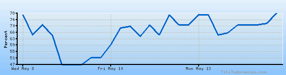
Humidity Variation Graph
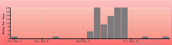
Wind speed
Weather Station: Grise Fiord Airport (latitude 76-25N, longitude 082-54W)
Local Time:
Grise Fiord is in the "America/Iqaluit" timezone.
The "America/Iqaluit" timezone uses a Standard Time (ST) / Daylight Saving Time (DST) alternation scheme, and it currently is in DST (since Sunday, 10 March 2024, 03:00 AM local time). During DST, the timezone abbreviation is EDT and the offset to Universal Time (UTC, GMT or Zulu) is -4:00 hours.
Grise Fiord will exit DST (returning to standard time) on Sunday, 3 November 2024, at 02:00 AM local time, when clocks will be turned backward 1 hour to Sunday, 3 November 2024, 01:00 AM local standard time. During ST, the timezone abbreviation is EST and the offset to UTC will be -5:00 hours.
Weather and Temperature in Canada