| Weather / Wyoming Weather Temperature |
Weather in Lander, Wyoming
Current Conditions (Sunday, April 28, 2024 at 23:53 America/Denver time)
Temperature: 43°F (6°C) |
Forecast Overview
Mon Apr 29 
55°F 37°F 13°C 3°C Partly cloudy skies.
detailsTue Apr 30 
46°F 30°F 8°C -1°C Sunny skies.
detailsWed May 1 
46°F 32°F 8°C -0°C Chance of light snow late at night.
detailsThu May 2 46°F 27°F 8°C -3°C More clouds than sun.
detailsFri May 3 
55°F 30°F 13°C -1°C Chance of snow after 6 pm.
detailsSat May 4 
55°F 32°F 13°C -0°C Chance of snow before sunrise.
detailsSun May 5 
66°F 41°F 19°C 5°C Overcast skies.
detailsMon May 6 73°F 41°F 23°C 5°C Sunny skies.
detailsTue May 7 63°F 45°F 17°C 7°C More sun than clouds.
detailsWed May 8 61°F 46°F 16°C 8°C Overcast skies.
detailsThu May 9 
54°F 39°F 12°C 4°C Chance of light snow in the morning.
detailsFri May 10 
50°F 34°F 10°C 1°C Chance of rain in the afternoon. Chance of snow after 6 pm.
detailsSat May 11 
43°F 34°F 6°C 1°C Chance of snow almost all day.
detailsSun May 12 34°F 30°F 1°C -1°C Chance of snow all day.
details
Detailed Forecast
| Monday, April 29 | sunrise: 06:12 sunset: 20:13 |
| Low around 37°F (3°C), high around 55°F (13°C). Partly cloudy skies. Wind: 22 mph (35 km/h). |
| Time | Skies | Conditions | Temp | Wind | Humidity | Soil Moisture |
| 00:00 03:00 | Overcast. | 37°F (3°C) | 9 mph (14 km/h) | 46% | 0.238% | |
| 03:00 06:00 | Overcast. | 38°F (3°C) | 7 mph (12 km/h) | 51% | 0.237% | |
| 06:00 09:00 | Overcast. | 45°F (7°C) | 10 mph (17 km/h) | 39% | 0.236% | |
| 09:00 12:00 | Mostly cloudy. | 51°F (11°C) | 13 mph (21 km/h) | 34% | 0.232% | |
| 12:00 15:00 | Considerable cloudiness. | 55°F (13°C) | 19 mph (31 km/h) | 32% | 0.227% | |
| 15:00 18:00 | Sunny. | 53°F (12°C) | 21 mph (34 km/h) | 35% | 0.224% | |
| 18:00 21:00 | Clear. | 47°F (8°C) | 22 mph (35 km/h) | 44% | 0.222% | |
| 21:00 00:00 | Clear. | 40°F (5°C) | 5 mph (8 km/h) | 57% | 0.222% |
| Tuesday, April 30 | sunrise: 06:10 sunset: 20:14 |
| Low around 31°F (-1°C), high around 47°F (8°C). Sunny skies. Wind: 23 mph (37 km/h). |
| Time | Skies | Conditions | Temp | Wind | Humidity | Soil Moisture |
| 00:00 03:00 | Clear. | 36°F (2°C) | 11 mph (18 km/h) | 42% | 0.222% | |
| 03:00 06:00 | Clear. | 31°F (-0°C) | 7 mph (11 km/h) | 48% | 0.222% | |
| 06:00 09:00 | Sunny. | 36°F (2°C) | 8 mph (13 km/h) | 23% | 0.221% | |
| 09:00 12:00 | Sunny. | 42°F (6°C) | 15 mph (25 km/h) | 17% | 0.219% | |
| 12:00 15:00 | A few passing clouds. | 47°F (8°C) | 18 mph (29 km/h) | 20% | 0.215% | |
| 15:00 18:00 | Sunny. | 46°F (8°C) | 23 mph (37 km/h) | 25% | 0.212% | |
| 18:00 21:00 | Clear. | 39°F (4°C) | 20 mph (32 km/h) | 36% | 0.211% | |
| 21:00 00:00 | Clear. | 35°F (2°C) | 8 mph (13 km/h) | 49% | 0.211% |
| Wednesday, May 1 | sunrise: 06:09 sunset: 20:15 |
| Low around 32°F (-0°C), high around 46°F (8°C). Chance of light snow late at night (after 9 pm). Estimated precipitation: 0.01 in (0.25 mm). More sun than clouds. Wind: 20 mph (32 km/h). |
| Time | Skies | Conditions | Temp | Wind | Humidity | Soil Moisture |
| 00:00 03:00 | Clear. | 35°F (1°C) | 6 mph (10 km/h) | 51% | 0.211% | |
| 03:00 06:00 | Mostly clear, with a few passing clouds. | 32°F (-0°C) | 5 mph (8 km/h) | 57% | 0.212% | |
| 06:00 09:00 | A few passing clouds. | 39°F (4°C) | 6 mph (9 km/h) | 41% | 0.212% | |
| 09:00 12:00 | Considerable cloudiness. | 44°F (7°C) | 11 mph (18 km/h) | 26% | 0.21% | |
| 12:00 15:00 | Times of sun and clouds. | 45°F (7°C) | 20 mph (32 km/h) | 22% | 0.206% | |
| 15:00 18:00 | Times of sun and clouds. | 40°F (4°C) | 18 mph (28 km/h) | 27% | 0.204% | |
| 18:00 21:00 | Considerable cloudiness. | 34°F (1°C) | 5 mph (8 km/h) | 38% | 0.204% | |
| 21:00 00:00 | Chance of light snow. Precipitation: 0.01 in (0.25 mm). | 33°F (1°C) | 11 mph (17 km/h) | 48% | 0.204% |
| Thursday, May 2 | sunrise: 06:07 sunset: 20:16 |
| Low around 26°F (-3°C), high around 46°F (8°C). Estimated precipitation: 0.02 in (0.4375 mm). More clouds than sun. Wind: 13 mph (21 km/h). |
| Time | Skies | Conditions | Temp | Wind | Humidity | Soil Moisture |
| 00:00 03:00 | Times of clear skies and clouds. Precipitation: 0 in (0.0625 mm). | 31°F (-1°C) | 4 mph (7 km/h) | 49% | 0.204% | |
| 03:00 06:00 | Clear. | 26°F (-3°C) | 3 mph (5 km/h) | 78% | 0.204% | |
| 06:00 09:00 | Considerable cloudiness. | 33°F (0°C) | 5 mph (8 km/h) | 57% | 0.205% | |
| 09:00 12:00 | Overcast. Precipitation: 0 in (0.125 mm). | 38°F (3°C) | 5 mph (8 km/h) | 46% | 0.204% | |
| 12:00 15:00 | Overcast. Precipitation: 0.01 in (0.25 mm). | 43°F (6°C) | 6 mph (9 km/h) | 37% | 0.204% | |
| 15:00 18:00 | Overcast. | 46°F (8°C) | 13 mph (21 km/h) | 30% | 0.202% | |
| 18:00 21:00 | Clear. | 39°F (4°C) | 2 mph (3 km/h) | 52% | 0.202% | |
| 21:00 00:00 | Clear. | 33°F (1°C) | 3 mph (5 km/h) | 66% | 0.202% |
| Friday, May 3 | sunrise: 06:06 sunset: 20:17 |
| Low around 30°F (-1°C), high around 55°F (13°C). Chance of snow in the evening and during the night (after 6 pm). Estimated precipitation: 0.1 in (2.5625 mm). More sun than clouds. Wind: 14 mph (23 km/h). |
| Time | Skies | Conditions | Temp | Wind | Humidity | Soil Moisture |
| 00:00 03:00 | Partly cloudy. | 31°F (-0°C) | 0 mph (0 km/h) | 72% | 0.202% | |
| 03:00 06:00 | Clear. | 30°F (-1°C) | 2 mph (3 km/h) | 74% | 0.202% | |
| 06:00 09:00 | Sunny. | 39°F (4°C) | 4 mph (6 km/h) | 49% | 0.202% | |
| 09:00 12:00 | Sunny. | 49°F (9°C) | 4 mph (6 km/h) | 31% | 0.201% | |
| 12:00 15:00 | Sunny. | 53°F (12°C) | 14 mph (22 km/h) | 30% | 0.198% | |
| 15:00 18:00 | More sun than clouds. Precipitation: 0 in (0.125 mm). | 50°F (10°C) | 14 mph (23 km/h) | 38% | 0.196% | |
| 18:00 21:00 | Chance of light snow. Precipitation: 0.01 in (0.1875 mm). | 42°F (5°C) | 9 mph (15 km/h) | 63% | 0.196% | |
| 21:00 00:00 | Chance of snow. Precipitation: 0.09 in (2.25 mm). | 36°F (2°C) | 8 mph (13 km/h) | 98% | 0.217% |
| Saturday, May 4 | sunrise: 06:05 sunset: 20:18 |
| Low around 31°F (-0°C), high around 55°F (13°C). Chance of snow before sunrise (from midnight to 6 am). Estimated precipitation: 0.16 in (4.125 mm). Partly cloudy skies. Wind: 7 mph (11 km/h). |
| Time | Skies | Conditions | Temp | Wind | Humidity | Soil Moisture |
| 00:00 03:00 | Chance of snow. Precipitation: 0.09 in (2.375 mm). | 33°F (1°C) | 5 mph (8 km/h) | 96% | 0.232% | |
| 03:00 06:00 | Chance of snow. Precipitation: 0.06 in (1.5625 mm). | 32°F (-0°C) | 5 mph (8 km/h) | 99% | 0.241% | |
| 06:00 09:00 | Mostly cloudy. Precipitation: 0.01 in (0.1875 mm). | 33°F (0°C) | 4 mph (7 km/h) | 92% | 0.241% | |
| 09:00 12:00 | Sunny. | 39°F (4°C) | 7 mph (11 km/h) | 67% | 0.242% | |
| 12:00 15:00 | Sunny. | 50°F (10°C) | 7 mph (11 km/h) | 44% | 0.239% | |
| 15:00 18:00 | Sunny. | 54°F (12°C) | 5 mph (8 km/h) | 31% | 0.235% | |
| 18:00 21:00 | Overcast. | 45°F (7°C) | 3 mph (6 km/h) | 54% | 0.233% | |
| 21:00 00:00 | Overcast. | 44°F (7°C) | 6 mph (9 km/h) | 48% | 0.231% |
| Sunday, May 5 | sunrise: 06:04 sunset: 20:19 |
| Low around 41°F (5°C), high around 66°F (19°C). Overcast skies. Wind: 18 mph (29 km/h). |
| Time | Skies | Conditions | Temp | Wind | Humidity | Soil Moisture |
| 00:00 03:00 | Overcast. | 43°F (6°C) | 5 mph (8 km/h) | 51% | 0.23% | |
| 03:00 06:00 | Overcast. | 42°F (5°C) | 4 mph (6 km/h) | 53% | 0.229% | |
| 06:00 09:00 | Overcast. | 54°F (12°C) | 3 mph (5 km/h) | 35% | 0.228% | |
| 09:00 12:00 | Overcast. | 63°F (17°C) | 11 mph (18 km/h) | 26% | 0.224% | |
| 12:00 15:00 | Overcast. | 65°F (19°C) | 18 mph (29 km/h) | 27% | 0.219% | |
| 15:00 18:00 | Overcast. | 64°F (18°C) | 13 mph (21 km/h) | 30% | 0.215% | |
| 18:00 21:00 | Overcast. | 54°F (12°C) | 8 mph (12 km/h) | 44% | 0.214% | |
| 21:00 00:00 | Considerable cloudiness. | 52°F (11°C) | 7 mph (12 km/h) | 49% | 0.214% |
| Monday, May 6 | sunrise: 06:02 sunset: 20:20 |
| Low around 41°F (5°C), high around 73°F (23°C). Sunny skies. Wind: 22 mph (35 km/h). |
| Time | Skies | Conditions | Temp | Wind | Humidity | Soil Moisture |
| 00:00 03:00 | Clear. | 44°F (7°C) | 3 mph (6 km/h) | 64% | 0.214% | |
| 03:00 06:00 | Clear. | 42°F (5°C) | 4 mph (6 km/h) | 67% | 0.214% | |
| 06:00 09:00 | Sunny. | 49°F (9°C) | 3 mph (5 km/h) | 52% | 0.213% | |
| 09:00 12:00 | Sunny. | 60°F (16°C) | 8 mph (13 km/h) | 38% | 0.21% | |
| 12:00 15:00 | Partly cloudy. | 72°F (22°C) | 6 mph (10 km/h) | 17% | 0.206% | |
| 15:00 18:00 | Sunny. | 71°F (22°C) | 22 mph (35 km/h) | 13% | 0.203% | |
| 18:00 21:00 | Clear. | 58°F (14°C) | 9 mph (15 km/h) | 30% | 0.202% | |
| 21:00 00:00 | Clear. | 51°F (11°C) | 7 mph (11 km/h) | 36% | 0.201% |
| Tuesday, May 7 | sunrise: 06:01 sunset: 20:22 |
| Low around 45°F (7°C), high around 62°F (17°C). More sun than clouds. Wind: 24 mph (39 km/h). |
| Time | Skies | Conditions | Temp | Wind | Humidity | Soil Moisture |
| 00:00 03:00 | Clear. | 48°F (9°C) | 6 mph (9 km/h) | 32% | 0.201% | |
| 03:00 06:00 | Clear. | 45°F (7°C) | 7 mph (12 km/h) | 37% | 0.201% | |
| 06:00 09:00 | Sunny. | 54°F (12°C) | 10 mph (16 km/h) | 28% | 0.2% | |
| 09:00 12:00 | Sunny. | 59°F (15°C) | 24 mph (39 km/h) | 24% | 0.197% | |
| 12:00 15:00 | More sun than clouds. | 62°F (17°C) | 15 mph (24 km/h) | 15% | 0.193% | |
| 15:00 18:00 | Overcast. | 61°F (16°C) | 11 mph (18 km/h) | 19% | 0.191% | |
| 18:00 21:00 | Overcast. | 53°F (12°C) | 4 mph (7 km/h) | 30% | 0.191% | |
| 21:00 00:00 | Overcast. | 51°F (11°C) | 2 mph (3 km/h) | 32% | 0.191% |
| Wednesday, May 8 | sunrise: 06:00 sunset: 20:23 |
| Low around 46°F (8°C), high around 60°F (16°C). Estimated precipitation: 0.03 in (0.875 mm). Overcast skies. Wind: 20 mph (32 km/h). |
| Time | Skies | Conditions | Temp | Wind | Humidity | Soil Moisture |
| 00:00 03:00 | Overcast. | 51°F (11°C) | 5 mph (9 km/h) | 29% | 0.191% | |
| 03:00 06:00 | Overcast. | 46°F (8°C) | 6 mph (10 km/h) | 41% | 0.191% | |
| 06:00 09:00 | Overcast. | 52°F (11°C) | 3 mph (5 km/h) | 41% | 0.191% | |
| 09:00 12:00 | Overcast. | 57°F (14°C) | 6 mph (9 km/h) | 26% | 0.189% | |
| 12:00 15:00 | Overcast. | 58°F (14°C) | 20 mph (32 km/h) | 29% | 0.187% | |
| 15:00 18:00 | Overcast. | 55°F (13°C) | 18 mph (28 km/h) | 36% | 0.185% | |
| 18:00 21:00 | Overcast. Precipitation: 0.01 in (0.25 mm). | 50°F (10°C) | 7 mph (11 km/h) | 50% | 0.188% | |
| 21:00 00:00 | Overcast. Precipitation: 0.02 in (0.625 mm). | 47°F (8°C) | 7 mph (11 km/h) | 62% | 0.194% |
| Thursday, May 9 | sunrise: 05:59 sunset: 20:24 |
| Low around 39°F (4°C), high around 53°F (12°C). Chance of light snow early in the morning (between 6 am and 9 am). Estimated precipitation: 0.05 in (1.25 mm). Overcast skies. Wind: 11 mph (18 km/h). |
| Time | Skies | Conditions | Temp | Wind | Humidity | Soil Moisture |
| 00:00 03:00 | Overcast. Precipitation: 0.01 in (0.25 mm). | 44°F (7°C) | 7 mph (12 km/h) | 57% | 0.197% | |
| 03:00 06:00 | Overcast. Precipitation: 0 in (0.125 mm). | 42°F (5°C) | 6 mph (9 km/h) | 59% | 0.197% | |
| 06:00 09:00 | Chance of light snow. Precipitation: 0.03 in (0.875 mm). | 44°F (7°C) | 7 mph (11 km/h) | 48% | 0.204% | |
| 09:00 12:00 | Overcast. | 48°F (9°C) | 4 mph (6 km/h) | 39% | 0.203% | |
| 12:00 15:00 | Overcast. | 52°F (11°C) | 3 mph (5 km/h) | 33% | 0.201% | |
| 15:00 18:00 | Overcast. | 52°F (11°C) | 11 mph (18 km/h) | 31% | 0.199% | |
| 18:00 21:00 | Mostly cloudy. | 43°F (6°C) | 8 mph (13 km/h) | 44% | 0.199% | |
| 21:00 00:00 | Overcast. | 39°F (4°C) | 6 mph (10 km/h) | 42% | 0.198% |
| Friday, May 10 | sunrise: 05:57 sunset: 20:25 |
| Low around 34°F (1°C), high around 50°F (10°C). Chance of rain late in the afternoon (between 3 pm and 6 pm). Chance of snow in the evening and during the night (after 6 pm). Estimated precipitation: 0.32 in (8.25 mm). Mostly cloudy skies. Wind: 14 mph (23 km/h). |
| Time | Skies | Conditions | Temp | Wind | Humidity | Soil Moisture |
| 00:00 03:00 | Overcast. | 39°F (4°C) | 6 mph (10 km/h) | 43% | 0.198% | |
| 03:00 06:00 | Sunny. | 36°F (2°C) | 5 mph (9 km/h) | 46% | 0.198% | |
| 06:00 09:00 | Overcast. | 45°F (7°C) | 3 mph (5 km/h) | 29% | 0.198% | |
| 09:00 12:00 | Overcast. | 48°F (9°C) | 7 mph (11 km/h) | 33% | 0.196% | |
| 12:00 15:00 | Overcast. Precipitation: 0.01 in (0.1875 mm). | 50°F (10°C) | 3 mph (5 km/h) | 37% | 0.194% | |
| 15:00 18:00 | Chance of light rain. Precipitation: 0.03 in (0.75 mm). | 44°F (7°C) | 14 mph (23 km/h) | 62% | 0.198% | |
| 18:00 21:00 | Chance of snow. Precipitation: 0.19 in (4.9375 mm). | 35°F (1°C) | 7 mph (11 km/h) | 97% | 0.248% | |
| 21:00 00:00 | Chance of snow. Precipitation: 0.09 in (2.375 mm). | 35°F (2°C) | 7 mph (12 km/h) | 84% | 0.252% |
| Saturday, May 11 | sunrise: 05:56 sunset: 20:26 |
| Low around 33°F (1°C), high around 43°F (6°C). Chance of snow most of the night and day, except late afternoon (from 3 pm to 6 pm). Estimated precipitation: 0.46 in (11.625 mm). Overcast skies. Wind: 16 mph (25 km/h). |
| Time | Skies | Conditions | Temp | Wind | Humidity | Soil Moisture |
| 00:00 03:00 | Chance of light snow. Precipitation: 0.02 in (0.4375 mm). | 35°F (1°C) | 8 mph (14 km/h) | 87% | 0.247% | |
| 03:00 06:00 | Chance of snow. Precipitation: 0.15 in (3.875 mm). | 34°F (1°C) | 8 mph (13 km/h) | 99% | 0.264% | |
| 06:00 09:00 | Chance of snow. Precipitation: 0.13 in (3.1875 mm). | 34°F (1°C) | 10 mph (15 km/h) | 90% | 0.271% | |
| 09:00 12:00 | Chance of snow. Precipitation: 0.05 in (1.3125 mm). | 36°F (2°C) | 13 mph (21 km/h) | 79% | 0.27% | |
| 12:00 15:00 | Chance of snow. Precipitation: 0.05 in (1.1875 mm). | 42°F (5°C) | 14 mph (23 km/h) | 59% | 0.266% | |
| 15:00 18:00 | Overcast. Precipitation: 0.01 in (0.1875 mm). | 43°F (6°C) | 16 mph (25 km/h) | 49% | 0.257% | |
| 18:00 21:00 | Chance of light snow. Precipitation: 0 in (0.125 mm). | 38°F (3°C) | 5 mph (8 km/h) | 67% | 0.252% | |
| 21:00 00:00 | Chance of snow. Precipitation: 0.05 in (1.3125 mm). | 34°F (1°C) | 4 mph (7 km/h) | 92% | 0.253% |
| Sunday, May 12 | sunrise: 05:55 sunset: 20:27 |
| Low around 29°F (-1°C), high around 35°F (1°C). Chance of snow all day (from 3 am to midnight). Estimated precipitation: 0.82 in (20.75 mm). Overcast skies. Wind: 12 mph (20 km/h). |
| Time | Skies | Conditions | Temp | Wind | Humidity | Soil Moisture |
| 00:00 03:00 | Overcast. Precipitation: 0.03 in (0.6875 mm). | 33°F (0°C) | 4 mph (7 km/h) | 80% | 0.25% | |
| 03:00 06:00 | Chance of light snow. Precipitation: 0 in (0.0625 mm). | 31°F (-1°C) | 2 mph (3 km/h) | 96% | 0.247% | |
| 06:00 09:00 | Chance of light snow. Precipitation: 0.02 in (0.5625 mm). | 33°F (1°C) | 5 mph (8 km/h) | 98% | 0.249% | |
| 09:00 12:00 | Chance of snow. Precipitation: 0.17 in (4.375 mm). | 31°F (-0°C) | 8 mph (13 km/h) | 100% | 0.259% | |
| 12:00 15:00 | Chance of snow. Precipitation: 0.17 in (4.3125 mm). | 32°F (0°C) | 9 mph (15 km/h) | 100% | 0.276% | |
| 15:00 18:00 | Chance of snow. Precipitation: 0.12 in (3.0625 mm). | 33°F (0°C) | 12 mph (20 km/h) | 100% | 0.285% | |
| 18:00 21:00 | Chance of snow. Precipitation: 0.19 in (4.75 mm). | 30°F (-1°C) | 10 mph (15 km/h) | 100% | 0.281% | |
| 21:00 00:00 | Chance of snow. Precipitation: 0.12 in (2.9375 mm). | 30°F (-1°C) | 7 mph (11 km/h) | 100% | 0.273% |
Climate Chart
Places with a similar climate: Riverton (WY), Cody (WY), Rapid City (SD), Gillette, Campbell County (WY), Helena (MT), Buffalo Johnson County (WY), Sheridan City/County (WY), Douglas, Converse County (WY), Great Falls (MT), Casper, Natrona County (WY), Rapid City, Meade County (SD), Challis (ID), Bozeman, Gallatin Field (MT).
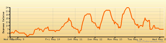
Temperature variation graph for the last seven days
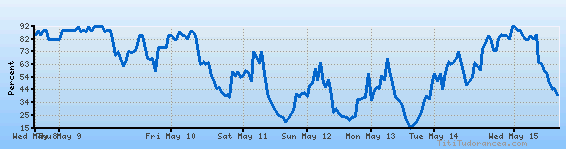
Humidity Variation Graph
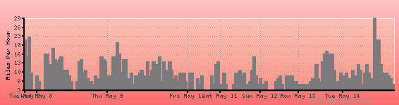
Wind speed
Weather Station: Lander (latitude 42-48-53N, longitude 108-43-41W)
Local Time:
Lander is in the "America/Denver" timezone.
The "America/Denver" timezone uses a Standard Time (ST) / Daylight Saving Time (DST) alternation scheme, and it currently is in DST (since Sunday, 10 March 2024, 03:00 AM local time). During DST, the timezone abbreviation is MDT and the offset to Universal Time (UTC, GMT or Zulu) is -6:00 hours.
Lander will exit DST (returning to standard time) on Sunday, 3 November 2024, at 02:00 AM local time, when clocks will be turned backward 1 hour to Sunday, 3 November 2024, 01:00 AM local standard time. During ST, the timezone abbreviation is MST and the offset to UTC will be -7:00 hours.
Weather and Temperature in Wyoming