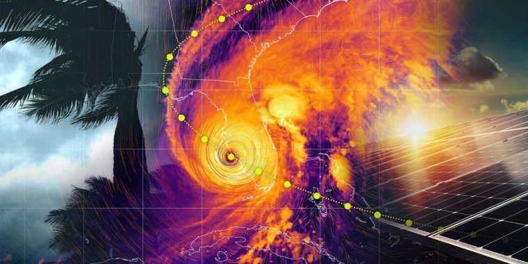
When hurricanes threaten tropical shores, “super grids” could come to the rescue. »
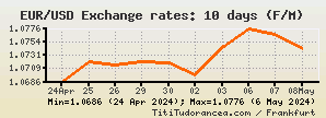
ECB Exchange Rates (April 26, 2024)
| 1 EUR | = | 1.0714 | USD | graph » | |
| 1 EUR | = | 89.3191 | INR | graph » | |
| 1 EUR | = | 7.7638 | CNY | graph » | |
| 1 EUR | = | 0.9779 | CHF | graph » | |
| 1 EUR | = | 0.85643 | GBP | graph » | |
| 1 EUR | = | 168.03 | JPY | graph » | |
| 1 EUR | = | 5.5208 | BRL | graph » | |


The Terra dos Gigantes (Land of the Giants) geopark in Uberaba, located in the Triângulo Mineiro region of Minas Gerais state, has been designated as a UNESCO (United Nations Educational, Scientific, and Cultural Organization) World Geopark. »

NIH and NSF jointly fund new research centers to better understand how ocean-related exposures affect people’s health. »

The discovery of a massive snake fossil in India suggests that giant serpents once roamed the Earth's warmer regions alongside various other creatures, researchers say. »

A study has found that the AI model GPT-4 significantly exceeds the ability of non-specialist doctors to assess eye problems and provide advice. »

Scientists at the Department of Energy’s Oak Ridge National Laboratory have developed a method that demonstrates how fiber-reinforced polymer composite materials used in the automotive, aerospace and renewable energy industries can be made stronger and tougher to better withstand mechanical or structural stresses over time. »

Chemists at the Department of Energy’s Oak Ridge National Laboratory have invented a more efficient way to extract lithium from waste liquids leached from mining sites, oil fields and used batteries. »

When it launches in October, the agency’s Europa Clipper spacecraft will carry a richly layered dispatch that includes more than 2.6 million names submitted by the public. »

The most surprising revelation from NASA’s Curiosity Mars Rover — that methane is seeping from the surface of Gale Crater — has scientists scratching their heads. »

In a new analysis of genetic susceptibility to kidney cancer, an international team of researchers has identified 50 new areas across the genome that are associated with the risk of developing kidney cancer. »

Cambridge researchers have identified genetic variants in two genes that have some of the largest impacts on obesity risk discovered to date. »


 In English. Units, exercises and related audio files (Travel, Hotel, Restaurant, Shopping, Medical and Banking English). »  In English. Over 1,300 high-quality audio files and about 100 self-study resources covering all the essential terminology related to accountancy. »  In English, French, Spanish, German and Italian. Over 5000 literary works, especially prose fiction, fables and fairy tales. » |


